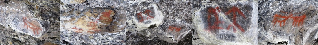
Discover Aborigional Cave Drawings at the Savona Caves
The local First Nations once had rituals and celebrations in and around the Savona Caves leaving behind authentic cave drawings for hikers to discover. Savona Mountain is an eroded shield volcano and the trail leading to the caves follows eroded volcanic ridges. The beautiful rock formations include agates and green opals providing countless treasures for rock hounds.
|
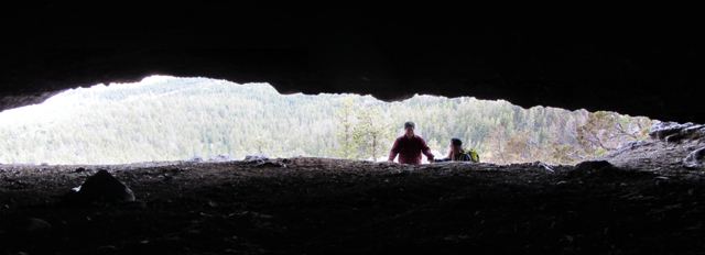
The site, which is also the location of a geocache, can be reached by hiking for 1.5-2 hours from the trailhead. For those unaware of the term, geocaching is an outdoor sporting activity in which the participants use a Global Positioning System (GPS) receiver or mobile device and other navigational techniques to hide and seek containers, called "geocaches" or "caches", anywhere in the world.
Beginning with 15-20 minutes of flat ground, the trail then goes straight up on a slope for about 45 minutes so make sure to wear good shoes. Don’t attempt the single cave to the left without rock climbing gear; instead head for the big crack to the right. April through November is definitely the best time to climb the 2km trail which brings you to an elevation of close to 4000 feet and can be quite steep in areas. |
|
HOW TO GET THERE...
The caves are within a 45-minute drive of downtown Kamloops. From Kamloops take the Trans Canada Highway towards Savona. Continue until you see the Savona Mill on your right hand side and also a gas station. Keep an eye out on your left hand side for Tunkwa Lake Road. The road is before the mill and gas station, so if you went past the gas station, turn around.
The caves are within a 45-minute drive of downtown Kamloops. From Kamloops take the Trans Canada Highway towards Savona. Continue until you see the Savona Mill on your right hand side and also a gas station. Keep an eye out on your left hand side for Tunkwa Lake Road. The road is before the mill and gas station, so if you went past the gas station, turn around.
|
Take a kilometre reading from the start of Tunkwa Lake Road, and continue along the main road. The road will turn to good gravel, continue on this road until Km 10.9 from here you can see the caves in the mountain on your right, high on the ridge. Move on to Km 11.1 where you will turn right off Tunkwa Lake Road and over a cattle guard. From this point go 0.5 Km, past the power lines, and just 20m past another road on your left. This will bring you to a fork in the road. The fork is not equal, the left side is the major road and the right is somewhat hidden--also there is a deep rut dividing the main, left road from the right fork. Turn to the right at this fork, and park just inside it. Walk up this right side road, and you will see it ends at a turn-around. This is the trailhead, and there should be some forestry ribbon, but the trailhead is pretty obvious. Stay on the main trail, which is well worn in. Cell phone service is usually available from top. For more information and a map, visit www.trailpeak.com .
|